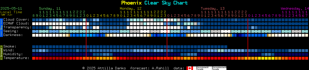
Summary: In the rows labeled "sky conditions", find a column of blue blocks. You can probably observe then.
Details:
Read the image from left to right. Each column represents a
different hour. The colors of the blocks are the colors from CMC's forecast maps for that hour.
The two numbers at the top of a column is the time. A digit 1 on top of a 3 means 13:00 or 1pm. It's local time, in 24hr format.
(Local time for Blackfoot is -7.0 hours from GMT.)
| Overcast | 90% covered | 80% covered | 70% covered | 60% covered | 50% covered | 40% covered | 30% covered | 20% covered | 10% covered | Clear |
The line, labeled Cloud Cover forecasts total cloud cover. The colors are picked from what color the sky is likely to be, with
Dark blue being clear.
Lighter shades of blue are increasing cloudiness and white is overcast. This forecast may miss low cloud and afternoon thunderstorms. When the forecast is clear, the sky may still be hazy, if the transparency forecast is poor.
CMC's text page explaining this forecast is
here.
| Too cloudy to forecast | Poor | Below Average | Average | Above average | Transparent |
The line, labeled Transparency, forecasts the transparency of the air. Here 'transparency' means just what astronomers mean
by the word:
the total transparency of the atmosphere from ground to space. It's calculated from the total amount of water vapor in the
air. It is somewhat independant of the cloud cover forecast in that there can be isolated clouds in a transparent air mass, and poor transparency can occur
when there is very little cloud.
Above average transparency is necessary for good observation of low contrast objects like galaxies and nebulae. However, open clusters
and planetary nebulae are quite observable in below average transparency. Large globulars and planets can be observed in poor
transparency.
A forecast color of white formally means that CMC didn't compute the transparency forecast because the cloud cover was over 30%. So it may
be possible to observe during a white transparency forecast, but the real transparency is usually yucky.
CMC's text page explaining this forecast is
here.
| Too cloudy to forecast | Bad 1/5 | Poor 2/5 | Average 3/5 | Good 4/5 | Excellent 5/5 |
The line, labeled Seeing, forecasts astronomical seeing.
(It's an experimental forecast.)
Excellent seeing means at
high magnification you will
see fine detail on planets. In bad seeing,
planets might look like they are under a layer of rippling water and show little detail at any magnification, but the view of galaxies is
probably undiminished. Bad seeing is caused by
turbulence combined with temperature differences in the atmosphere. This forecast attempts to predict turbulence and temperature differences that affect seeing for
all altitudes.
Bad seeing can occur during perfectly clear weather. Often good seeing occurs during poor transparency. It's because seeing is not very related to the
water vapor content of the air.
The excellent-to-bad seeing scale is calibrated for instruments in the 11 to 14 inch range. There are some more details in
CMC's seeing forecast page.
No computer model forecasts convective heating well, so consider the seeing forecasts for daytime
hours to be less accurate. Seeing is forecast for 3-hour blocks, so triples of seeing blocks will show the same color.
A white block on the seeing line means that there was too much cloud (>80% cover) to calculate it.
Note also that you may observe worse seeing though your telescope than what a perfect seeing forecast would predict. That is because
tube currents
and ground seeing mimic true atmospheric seeing. You may also observe better seeing than predicted here when observing
with an instrument smaller than 11 inches.
| -4 | -3 | -2 | -1 | 0 | 1.0 | 2.0 | 3.0 | 3.5 | 4.0 | 4.5 | 5.0 | 5.2 | 5.4 | 5.6 | 5.8 | 6.0 |
The line labeled darkness is not a weather forecast. It shows when the sky will be dark,
assuming no light pollution and a clear sky.
Black is a dark sky. Deep blue shows interference from moonlight. Light blue is full moon. Turquoise is twilight. Yellow is dusk and white
is daylight. For those who prefer numbers, the scale is also calibrated. The numbers are the visual limiting magnitude at the zenith.
(The brightness of the faintest star a standard observer can see straight up.) Mouse over a darkness block for details.
It is based on Ben Sugerman's Limiting Magnitude
calculations page. It takes into account the sun's and moon's position, moon phase, solar cycle and contains a scattering model of the atmosphere.
It doesn't consider light pollution, dust, clouds, snow cover or the observer's visual acuity. So your actual limiting magnitude will often
be different.
| >72 km/hr | 46 to 72 km/hr | 28 to 45 km/hr | 19 to 27 km/hr | 9 to 18 km/hr | 0 to 8 km/hr |
This forecasts wind speed at about tree-top level. The wind forecast won't determine whether or not you can observe,
but it may affect your comfort and the type observing you might be limited to. In particular, long-focal length astrophotography, or observing with large
dobsonians require light wind conditions. High wind may be particularly dangerous for larger truss-tube dobsonians which must be disassembled in the
vertical position.| <25% | 25% to 30% | 30% to 35% | 35% to 40% | 40% to 45% | 45% to 50% | 50% to 55% | 55% to 60% | 60% to 65% | 65% to 70% | 70% to 75% | 75% to 80% | 80% to 85% | 85% to 90% | 90% to 95% | 95% to 100% |
This forecasts ground-level relative humidity.
Humidity variations can indicate the likelihood of optics and eyepieces dewing.
But dewing is not simply correlated to relative humidity. Dewing tends to happen when the sky is clear, the temperature is dropping and there
isn't much wind. Being on a hilltop or in a small valley can make the difference between no dew and dripping telescopes. Unfortunately, the
humidity forecast does not have the spatial resolution to know about small hills, valleys, or observatory walls. All of which can reduce dewing.
A sudden spike in the humidity forecast, an hour or so after the cloud forecast predicts a sudden transition from cloudy to clear, when there is no wind, means that ground fog
will form.
Also, when the cloud forecast is opaque and the humidity forecast is 95%, rain is likely: a good time to cover the telescopes.
Since there are many different levels in this forecast, with similar looking colors, it's best to activate the
"explain colors when you mouse over" to interpret the colors.
| < -40C | -40C to -35C | -35C to -30C | -30C to -25C | -25C to -20C | -20C to -15C | -15C to -10C | -10C to -5C | -5C to 0C | 0C to 5C | 5C to 10C | 10C to 15C | 15C to 20C | 20C to 25C | 25C to 30C | 30C to 35C | 35C to 40C | 40C to 45C | > 45C |
This forecasts temperatures near the ground. While temperature variations won't determine if you
can observe, the forecast can be handy choosing clothing for cold observing conditions. (In general, dress as if it were
20 degrees F or 10 degrees C colder than the forecast.) Observers with thick primary mirrors should take note of
falling temperature conditions because their mirrors may require additional cooling to reach equilibrium and so prevent
tube currents.Cold temperatures also mean reduced battery capacity, stiffer lubricants, stiffer electrical cables and slower LCD displays.
Camera sensors will have reduced noise. But, in general, electronics have a lowest temperature at which they will work.